
Welcome to the Tatra Mountains Virtual Tourist. These pages contain the tourist trails diagram, over 300 pictures and some information about the Tatras.
Welcome to the Tatra Mountains Virtual Tourist. These pages contain the tourist trails diagram, over 300 pictures and some information about the Tatras.
 Where are the Tatra Mountains ?
 The Tatras view from satellite
 The mountain huts in the Tatras
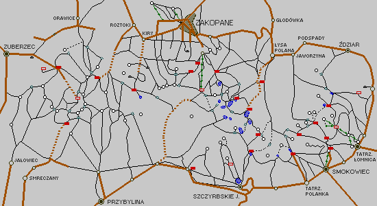
The following diagram shows many objects of Polish and Slovak Tatras, including tourist trails, roads, peaks, mountain huts, cities and villages, etc. It is Main Map of the Tatras. For zooming in, click on selected point of this map.
 |
You can select the Tatras region by name instead of using above map, or you can select the pictures group, single picture or described picture from the list by clicking on the one of the following buttons:
 List of the Tatras regions
 Groups of pictures list
 List of all pictures
 List of all described pictures
The Tatra Mountains pictures (except these) are available on anonymous ftp site:
 Poznan:
ftp.man.poznan.pl /pub/images/tatry
Poznan:
ftp.man.poznan.pl /pub/images/tatry
Any comments and suggestions are welcome.